First comprehensive measurements of sea level changes in the Baltic Sea and the North Sea
Precise data for improved coastline protection: Led by DGFI-TUM, an international team of researchers has created the first comprehensive data sets of regional sea level rise in the North Sea and the Baltic Sea, including coastal areas and regions covered by sea ice. The data sets provide new insights into long-term and seasonal seal level changes over the past quarter century. This information is of vital importance for planning protective measures and for understanding dynamic processes in the oceans and the climate system.
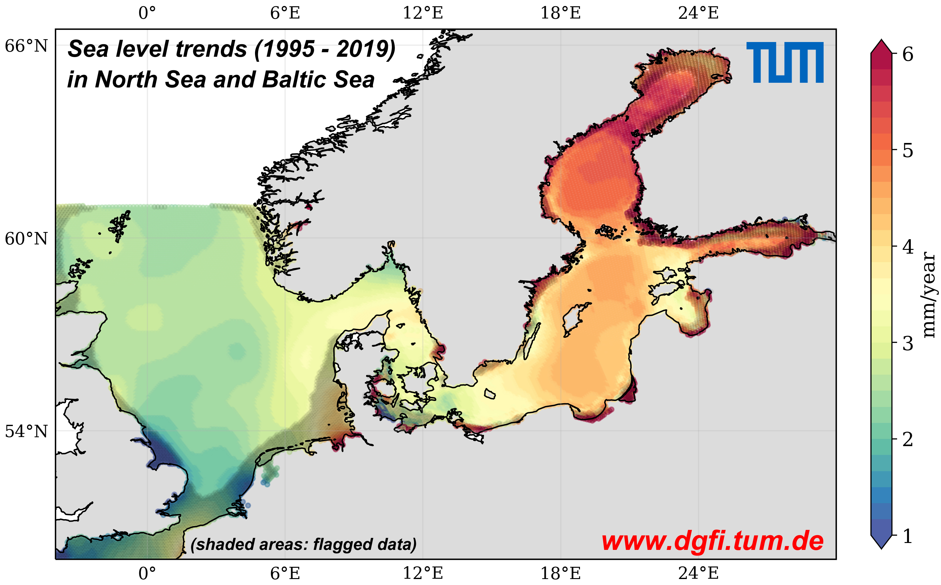
Especially near coastlines, where many cities and industry facilities are located, the quality and quantity of data collected by the satellites are compromised by strong perturbances of the radar signal. Another problem is sea ice, which covers parts of the oceans in winter, and is impenetrable to radar. In the ESA Baltic Sea Level project (Baltic SEAL) the researchers developed algorithms to process the measurement data from radar satellites to permit precise and high-resolution measurements of sea level changes even in coastal areas and beneath sea ice. In this effort, the Baltic Sea can be seen as a model region since the complex shape of the coastline and sea ice make the data analysis particularly difficult. Analytical methods that work here can be easily adapted to other regions. Hundreds of millions of radar measurements taken between 1995 and 2019 were processed in a newly developed multi-stage process, comprising the identification of signals from the ice-covered sea water in the radar reflections produced along cracks and fissures, the development of new computational methods to achieve better quality of sea level data close to land, and finally the calibration and combination of measurements from the various satellite missions.
The analysis of these data for the Baltic Sea shows that the sea level has risen at an annual rate of 2-3 millimeters in the south, on the German and Danish coasts, as compared to 6 millimeters in the north-east, in the Bay of Bothnia. The cause of this above-average rise: Strong south-westerly winds connected to the NAO drive the waters to the north-east. The developed method has also been applied to the North Sea, where the sea level is rising by 2.6 millimeters per year, and by 3.2 millimeters in the German Bight.
The data sets Baltic SEAL and North SEAL of sea level changes are available for download in our Science Data Products section. Methods and results are described in the respective publications Absolute Baltic Sea Level Trends in the Satellite Altimetry Era: A Revisit (Frontiers in Marine Science, 2021, doi: 10.3389/fmars.2021.647607, [PDF]) and North SEAL: A new Dataset of Sea Level Changes in the North Sea from Satellite Altimetry (Earth System Science Data, 2021, doi: 10.5194/essd-13-3733-2021, [PDF]).
The study is also subject of a current TUM press release (English, German).
Arcisstraße 21
80333 München