Combination of space geodetic observations for the determination of mass transports in the cryosphere and their impact on Earth rotation (CIEROT)
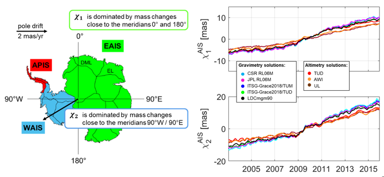
Increasing ice loss from the Antarctic and Greenland Ice Sheets (AIS/GIS) due to global warming influences the orientation of the Earth's rotation axis with respect to an Earth-fixed reference frame (polar motion) over decadal time scales. The effect of these mass redistributions from the cryosphere to the oceans on polar motion is usually described by equatorial effective angular momentum functions (EAM). The project CIEROT aims to improve the modelling of these EAM functions by combining gravimetric and geometric observation data:
- temporal changes of the Earth's gravity field from observations of the satellite missions GRACE (Gravity Recovery and Climate Experiment) and GRACE-FO,
- temporal changes of the ice sheet thickness from observations of altimeter satellites such as ENVISAT, ICESat and CryoSat-2.
GRACE gravity field observations provide the advantage that ice mass changes can be directly observed for the entire AIS and GIS. But the accuracy of GRACE ice mass change estimates is limited by signal noise (meridional error stripes), leakage and uncertainties of glacial isostatic adjustment (GIA) models. One goal of the project is therefore to develop a novel approach to improve the EAM functions derived from GRACE data addressing the above-mentioned limitations. Satellite altimetry, on the other hand, provides detail information at a much higher spatial resolution. But the accuracy of altimetry measurements of ice thickness is limited by waveform tracking and slope-related displacement errors (especially in rugged terrain). The unknown density of ice in the conversion from ice volume to ice mass contributes further uncertainties.
In order to reduce systematic and random errors in data processing and to increase the resolution and robustness of ice mass-related EAM functions, CIEROT aims to combine gravity and altimeter data. The project makes use of different GRACE gravity field solutions and multi-mission satellite altimetry data to assess the accuracy of the derived EAM functions and provide improved information on the contribution of ice melting in Antarctica and Greenland on polar motion.

Selected Publications
 (Open Access)
 (Open Access)
 (Open Access)
Arcisstraße 21
80333 München