Interactions of Low-orbiting Satellites with the Surrounding Ionosphere and Thermosphere (INSIGHT)

The project aims on the investigation of thermospheric and ionospheric dynamics for the purpose of studying the interactions of these layers with geodetic sensors on space missions (see figure right).
As one of the main project goals a climatological analysis of the thermosphere and the ionosphere-thermosphere coupling based on CHAMP and GRACE data as well as on SLR observations will be performed. The derived model will be used to improve GOCE gravity field recovery and to refine the thermospheric modelling in SLR analysis.
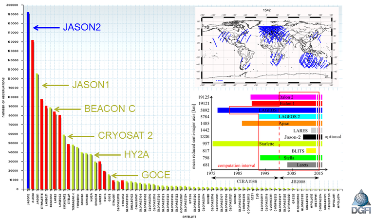
For many years DGFI-TUM acts as an official analysis center of the International Laser Ranging Service (ILRS). Additionally, DGFI-TUM focuses on the integrated estimation of fundamental geodetic parameters such as station coordinates, Earth Orientation Parameters (EOP) and low degree coefficients of the Earth’s gravitational potential with a high temporal resolution by combining data of up to 11 spherical satellites (see figure below). The ‘DGFI Orbit and Geodetic parameter estimation Software’ (DOGS) allows to process data of both spherical passive satellites such as LAGEOS-1/2 and non-spherical active satellites such as JASON-1/2 or GOCE. The satellites with altitudes below 1500 km are sensitive to disturbing forces such as the atmospheric drag. Using SLR observations to Low-Earth-Orbiting (LEO) satellites and computing the physical drag coefficient from a Gas-Surface-Interaction model we determine scale factors to improve the thermospheric density computed from given empirical thermosphere models.
The following list gives the overview of all work packages at DGFI-TUM within the project period:
- Sensitivity analysis of SLR observations to thermospheric parameters
- Setup of an adjustment model for thermospheric parameters
- Estimation of thermospheric scale factors from SLR observations to LEO satellites, such as ANDE-P, ANDE-C and SpinSat
- Combination of various SLR missions
- Optimal parameterization of thermospheric parameters
- Combined estimation including the SWARM mission

Arcisstraße 21
80333 München