Exploitation of the potential of the SLR-tracked altimetry and GNSS satellites for determination of global geodetic parameters (PotS)
Satellite Laser Ranging (SLR) is a geodetic space technique used to determine parameters such as coordinates and velocities of globally distributed SLR ground stations, the origin and scale of terrestrial reference frames (TRF), Earth rotation parameters and low-degree coefficients of the Earth's gravity field. These parameters are important for the investigation of numerous (geo)scientific phenomena such as plate tectonics, Earth rotation, time measurement, post-glacial rebound, changes in the Earth's mass distribution, precise orbit determination for near-Earth satellites, monitoring of global and regional sea level changes and many others. Practical applications that also benefit from SLR measurements include navigation on ground and in space.
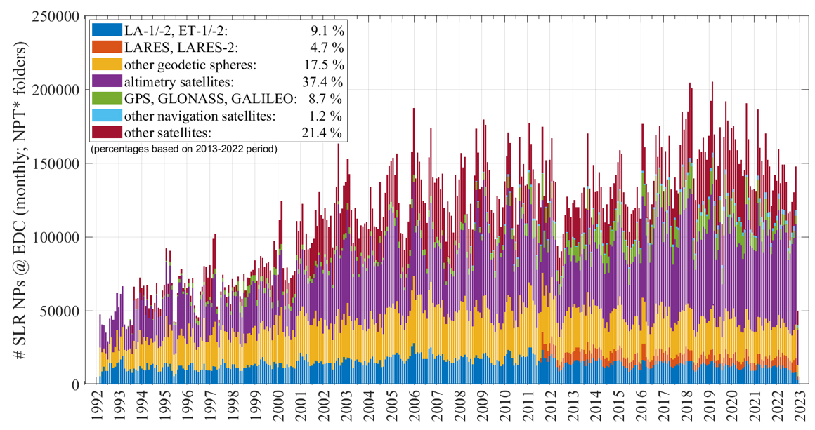
However, until recently, only four spherical satellites, namely LAser GEOdynamics Satellite-1/-2 (LAGEOS-1/2) and Etalon-1/2, which account for only 9.1 % of the total SLR observations, were used to determine the above-mentioned TRF parameters. At the same time, there are two groups of satellites observed with SLR that are available over three decades from 1992 to the present. These are about ten altimetry satellites and over a hundred GNSS (Global Navigation Satellite System) satellites, for which about 37.4 % and 9.9 %, respectively, of the total number of SLR observations are available, i.e. a total of 47.3 % (see Figure). This is around five times more than for the four spherical geodetic satellites currently in use.
The main objective of this project is to investigate and utilise the potential of extending the commonly used SLR constellation with four spherical satellites by non-spherical altimetry and GNSS satellites in order to determine global geodetic parameters more precisely and consistently. Due to their different orbital characteristics, the satellites have individual sensitivities to the different parameters. This means that the inclusion of these satellites in the SLR solutions will contribute to further stabilisation and decorrelation of the estimated parameter groups.
Selected Publications
Arcisstraße 21
80333 München