Pro- and retrospective highly accurate and consistent Earth Orientation Parameters for geodetic research within the Earth system sciences (PROGRESS)
Accurate knowledge of the Earth’s orientation and rotation in space is essential for a broad variety of scientific and societal applications such as near-Earth and deep space navigation, global positioning, the measurement of time or the monitoring of global change phenomena. The so-called Earth Orientation Parameters (EOP) describe the position of the Earth’s rotation axis as seen from space (Celestial Intermediate Pole (CIP) offsets ΔXCIP and ΔYCIP) and as seen from Earth (Polar Motion (PM) or Terrestrial Intermediate Pole (TIP) offsets xpole and ypole). Moreover, the EOP describe the spin of the Earth around its rotation axis (length-of-day (LOD), ΔUT1). The subset of the Earth Rotation Parameters (ERP), namely PM, LOD, ΔUT1 and their rates, are determined from the combined analysis of observations of the four geodetic space techniques Very Long Baseline Interferometry (VLBI), Satellite and Lunar Laser Ranging (SLR, LLR), Global Navigation Satellite Systems (GNSS), and Doppler Orbitography and Radiopositioning Integrated by Satellite (DORIS). Current EOP combination approaches, however, lack consistency and do not fulfil state-of-the-art accuracy requirements (see Figure).
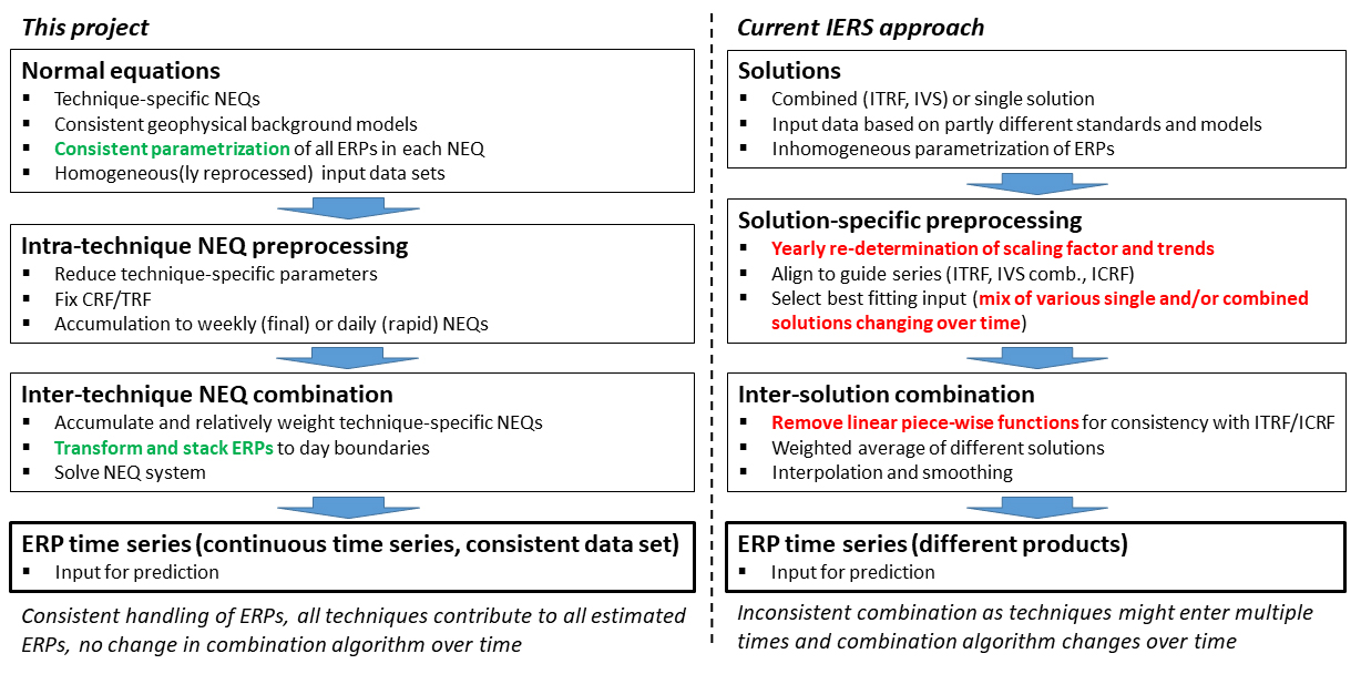
The PROGRESS project, which is carried out by DGFI-TUM in cooperation with TUM's Chair of Satellite Geodesy and the German Research Center for Geosciences Potsdam (GFZ), aims to develop an optimal combination strategy of final and rapid ERP together with a prediction that incorporates both observed Earth rotation information and predicted effective angular momentum (EAM) data. A main focus is on establishing a consistent parameterization, independent from the sensitivity of the observations to individual parameters. Technique-specific ERP biases will be mitigated and a sophisticated constellation-dependent modification of the functional model for LOD determination with GNSS will be investigated. The ERP prediction will employ high-precision EAM data incorporating the hydrological angular momentum of the LISFLOOD hydrological model and achieve a longer prediction period compared to conventional ERP prediction approaches.
Since the independent processing of geophysical model data in the EAM domain and geodetic data in the EOP domain can lead to inconsistencies, Kalman filter and/or AI methods will merge the space-geodetic and geophysical model-based processing into a single combination/prediction algorithm. The outcome of this project will thus be a processing strategy for a consistent and rigorously realized retro- and prospective ERP time series based on both geodetic and geophysical data.
Scientific challenges:
- Complete harmonization of the ERP parameterization in the Normal Equations (NEQs)
- Stable datum realisation of epoch-wise combined parameter solutions (via information filter)
- Consistent and rigorous combination of retrospective and prospective (predicted) ERP
- Smoothing and stabilization of the combined solution by introducing physical EAM information from the past into the combination process via Kalman filter. This is particularly important for the initial value of the ERP prediction.
- Enhanced EAM prediction with improved wind analysis and forecast data using AI methods.
Arcisstraße 21
80333 München