Space Weather
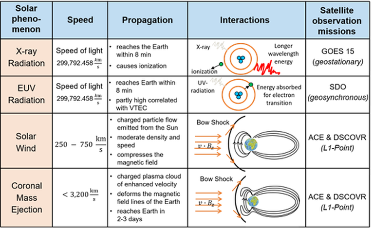
Space weather describes physical processes mainly caused by the Sun’s radiation of energy. The Table displays the most important solar phenomena such as EUV-, X-radiation, solar wind and coronal mass ejections (CME). The manifestations of space weather are multiple, e.g., the variations of the Earth’s magnetic field or the changing states of the upper atmosphere, i.e. the ionosphere and the thermosphere. The most extreme known space weather event happened on September 1st 1859 – the so-called Carrington Storm. Prominent recent, but weaker events are the Halloween Storm on October 28th to 30th 2003, the Bastille Day Event on July 14th 2000 or the St. Patrick’s Storm on March 17th 2015.

GGOS Focus Area "Geodetic Space Weather Research" (FA-GSWR)
The potential strength of severe space weather events and their impact on modern society, e.g. the interruption of satellite services including GNSS and communication systems, have brought several countries such as the US and the UK to recognize the necessity, e.g., of studying these impacts scientifically. As a consequence of these activities the Focus Area on Geodetic Space Weather Research (FA-GSWR) was implemented under the umbrella of GGOS within the IAG. The FA-GSWR is chaired by DGFI-TUM. The following statements summarize why geodesy has to cover scientific research on the coupled thermosphere-ionosphere system: Geodesy
-
deals with the ionosphere, since the measurements of most of the space-geodetic observation techniques are depending on the properties of the ionosphere along the ray path of an electromagnetic wave travelling from the transmitter to the receiver,
-
deals with the thermosphere, since the thermospheric drag is the most important deceleration effect on LEO satellites and objects in the re-entry stage,
-
has a long history and large experience in developing and using sophisticated analysis techniques and modelling approaches.
Consequently, the main objectives of the FA-GSWR are
-
the development of improved ionosphere models,
-
thedevelopment of improved thermosphere models
-
to study of the coupled processes between the thermosphere and the ionosphere
-
improved understanding of space weather events and their monitoring by space observations
(geodetic and non-geodetic).
The first objective aims at the high-precision and the high-resolution (spatial and temporal) modelling of the electron density. This finally allows to compute a signal propagation delay, which needs to be used in many geodetic applications, in particular in positioning, navigation and timing (PNT). Moreover, it is also important for other techniques using electromagnetic waves, such as satellite- or radio-communications. Concerning the second objective, satellite geodesy will obviously benefit when working on POD. Additionally, there are further technical matters like collision analysis or re-entry calculation, which will become more reliable when using high quality thermosphere models. The third objective links the first two objectives by introducing physical laws and principles such as continuity, energy and momentum equations and solving partial differential equations. The fourth objective finally relates the improved understanding of space weather events to the monitoring techniques and vice versa.
Geodetic space weather research has to be based on the use and combination of all space-geodetic observation methods, the use of Sun observations from solar missions, data assimilation strategies, real-time modelling for prediction and the development of deterministic and stochastic forecast approaches. Much more details can be taken from the GGOS web site of the FA-GSWR.
Selected Publications
 (Open Access)
Arcisstraße 21
80333 München